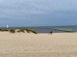
Today we drove a 100 mile loop in northwestern Michigan to visit some lighthouses and the unique sand dunes of eastern Lake Michigan. Heading straight west from Traverse City we drove to the lakeshore town of Frankfort MI. The Frankfort North Breakwater Lighthouse is very much a part of the city's heritage that they have incorporated it into the arch as you enter the city.
We drove through the quaint downtown area to the city beach and the north and south breakwater walls. At the end of the south breakwater is a harbor light, pretty common of lake harbors. The original light was built in 1873 and was accessed by an elevated catwalk. The light and the lighthouse mark the entrance to a manmade channel that connects Lake Betsie with Lake Michigan.We parked in a city lot and walked along the beach on a paved sidewalk that separates the beach from several beautiful homes. This walk provided a great view of the lighthouse out on the breakwater. The area was becoming busy this Friday morning. We were lucky to find a parking spot. Families were staking out their areas on the beach. A few brave soles had waded into the chilly Lake Michigan water for a swim. Others were trying their luck fishing from the breakwater.The sidewalk continues right down to the breakwater pier. From there we headed out to the lighthouse. The light waves were crashing on the rocks and the side of the breakwater.
The walk out to the lighthouse is just shy of a 1/4 mile. We passed several others out investigating the lighthouse and some fishermen. Soon we arrived.
On the north breakwater is the pyramid-shapes Frankfort North Breakwater Lighthouse. This lighthouse was built in 1912 and was transferred from the Coast Guard to the City of Frankfort in 2011. Since acquired by the city, there is an initiative on the repair it as it badly needs some corrosion control!
On the way back and looking north the Lake Michigan sand dunes are evident. We will see more of these dunes as we head further north today.
Heading north a short distance from Frankfort is the Point Betsie Lighthouse. It was built between 1854 and 1858. A life saving station was added in 1875. The focal plane of the light is 52 feet above lake level. Before it was automated it was affixed with a fourth order Fresnel lens.
In 2010 this lighthouse received the "Governor's Award for Historic Preservation". The association that maintains the lighthouse has over 300 members and they are obviously passionate about what they do.
We finished up here at Point Betsie Lighthouse and continued a few miles north to Empire MI and the Robert H. Manning Memorial Lighthouse. The city of Empire was named after an ice-bound schooner "Empire" in 1865. This area is surrounded by the Sleeping Bear Dunes National Lakeshore. Empire's claim to fame was it's hardwood mill that burned down in 1917 and was not rebuilt. This lighthouse was constructed in 1991 as a tribute to Mr. Robert H. Manning, a lifelong resident of Empire. It is a functional navigation aid officially known as the "Manning Light".
We departed Empire and drove to the Sleeping Bear Dunes National Lakeshore park. The first area we explored was the "Dunes Climb".
We are glad we spoke with the park ranger as we drove in as many climb the dunes expecting a grand view of Lake Michigan at the top only to be greeted by another mile of sand dunes before the lake comes into view!
The ranger suggested we drive a couple miles south to the Pierce Stocking Scenic Drive where there are 12 pull-offs offering various views of the sand dunes, Lake Michigan and the area around. That sounded like a great plan so off we went.
The centerpiece of the area is a building that was first built as a warehouse and then was converted into a cannery for cherry's. It is now a boathouse museum.
In the corner of the museum was a lighthouse display, and the volunteer dropped the rope so I could enter and get some closer pictures. They have the DCG-36 (directional code beacon) light and lense the North Manitou Shoals "Crib" Lighthouse after it was automated in 1980.
There were also models of both Manitou lighthouses. The volunteer pointed out the lighthouses to us but the overcast conditions prevented a clear view.
Tomorrow (Saturday) we will head north from Traverse City to investigate the Grand Traverse Lighthouse. One the way back we might stop at the Northern Latitude Distillery to sample some Mackinac Island Fudge Chocolate Liqueur. Full disclosure, we already sampled it. It will be a purchase!!


No comments:
Post a Comment